Copyright © 2008 The Official website of MUNICIPALITY OF BINANGONAN
Website Design by: Mike M. Mendoza
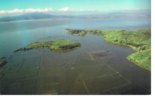
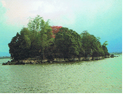
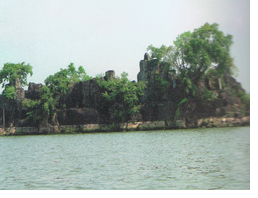
Talim Island
A dagger-shaped island at the heart of Laguna de Bay, Talim
Island is endowed with mountains and hills such as Susong
Dalaga and Dolores Hills. Islets include Pulong Ithan, The Three
Islets of Bunga, Malahi and Pulong Gitna. Hot springs in
Ginoong Sanay, Tabon and Binitagan also exits. There are also
fish pens located at the center of the lake and the water
nearer the shore were developed for swimming, boating,
sailing, water sports and other activites.
NATURAL RESOURCES ENDOWMENTS
Land Use Potential Based on Pedo-Ecological Zones
There are three pedo-ecological zones identified in the
municipality namely:
a)Warm Lowland, 8% slope, 100 m elevation, 25 degree's
Centigrade
b) Warm Cool Upland, 18% slope, 100-500 m. elevation, 22.5
degrees C, 18% slope, 400 m. elevation, 25 degree C.
The first PEZ comprising 243 hectares or 3.34% is used as residential, industrial, infrastructure and other social amenities. The second PEZ, the biggest at 79.89% or 5,808 hectares, is ideal for the cultivation of annual and perennial crops. The third PEZ has 3.22% or 324 hectares, and needs soil cover like fruit trees and other permanent crops to prevent land degradation and soil erosion. The rest, with 13.55% or 985 hectares, are considered as miscellaneous land type and include the built up areas, coastal, open pit, quarry, kaingin and water bodies.
There are twelve identified Land Management Units as shown in Table 6. Five for the Warm Cool Upland PEZ, three for the Warm Lowland, two for the Warm Cool Hillyland, and two for the miscellaneous land type.
TABLE 6:DISTRIBUTION OF VARIOUS LMU'S BY PEDO-ECOLOGICAL ZONES
Pedo Eco ZoneNat'l. LMU SymbolOld LMU SymbolLand FormTypeTotal Area Hectares:%
Warm LL 15 12 Broad Alluvial Plain 2 0.024
8% slope 14 14 Narrow Alluvial Plain 212 2.92
25 deg. C 19 19 - do - 29 0.40
Sub-total 243 3.34
Warm Cool
Upland4320Minor AlluvialPlain 5547.62
<18% slope 52 31Foot slope Piedmont 1965 27.03
100-500 m.7058Plateau310.43
8-18% slope
400 m.82m85Volcanic hills1181.62
>22.5C8191Volcanic hills314043.19
Sub-total500879.89
-Warm cool
Hillyland11165Sedimentary hills1081.49
>18% slope
>500m22.5C11554Plateau1261.73
Sub-total2343.22
-Misc. Land
Type191171Miscellaneous1121.54
180177- do -1301.79
--- do -74310.22
-Sub-total985100%
TOTAL 7,270 100%
Source: Municipal Assessor's Office
2.Forest Resources
The 273 hectare-forest area has no timberland of dipterocap species. Only minor forest products are grown such as: ipil-ipil, madre de cacao and shrubs used as firewood or made into charcoal; bamboos used as construction and handicraft materials; and fruit trees like mango, atis, tamarind and santol.
The rapid decrease of forest in the mainland is attributed to the development of housing subdivisions. The island portion has lesser degree of deforestation because it is still untouched by land developers. However, negotation in the Talim Island is also being threatened due to charcoal making activities of the people.
3.Mineral Resources
There are no metallic minerals in Binangonan. There exist only non-metallic deposits used as construction materials. Table 7 & 8 would reflect the types of non-metallic resources in the municipality.
TABLE 7:NON-METALLIC RESERVES
LocationDepositMetric Tons
Binangonan-San GuillermoLimestone202,878,022
Binangonan-CardonaRock Aggregates45,360,000
Binangonan-San GuillermoTuff (Adobe)38,321,145
TABLE 8:NON-METALLIC RESERVES
LocationOperatorPositive & Prob.Grade or Reserve (MT)Status Analysis
Mambog Binangonan- Cardona Concete Aggregates, Inc. 45,360,000 Rock Aggregates Geologically Investigative
Pantok (Quarry) Non operation 38,321,425 Tuff (adobe) Producing
Pantok (Quarry) Non operation 198,878,022(limestone) 88 % CaCO3 Producing
Source: Phil. Non-Metallic Ore Reserves, Mines & Geo-Science Bureau
4.Water Resources
Tutulo, Mahabang Parang - weak flow
Ginoong Sanay Hot Spring - weak flow
Ray Tupas Spring, Bilibiran - source of Bilibiran river
Abundant ground water storage being adjacent to the Laguna Lake basis. It is a great potential for commercial water cooperatives and water utility companies and also in the development of water resources, and treatment plant.
The degration of Laguna Lake that will affect the water table particularly artesian wells due to waste discharge from industries and domestic waste around the lake. Siltatation to Lake and River system due to human intervation.
5.Fishery Resources
As one of the major occupations in 33 coastal barangays, fishing is engaged in by small and marginal fisherfolks using baklad, panti, bubo, pangahig, sakag, and dala as well as by medium and big fish farming operators with their fishpens and fishcages. Traditional fishing methods catch native and seasonal species like dulong, ayungin, biya, kanduli, hipon, suso, and gurami. Fishpens and fishcages produce tons of tilapia, bangus, big-head carps and catfish supplying the needs of the municipality including Metro Manila, Cavite, Laguna and Batangas.
The number of registered fishpens in the municipality of Binangonan as of 2004 is seventeen (17) with the total area of 543.000 hectares or 5,430,000 square meters. The long battle between the LLDA and local government units (LGU) over the authority to issue fishpen permits has resulted in uncontrolled growth of fishpens displacing small and marginal fishermen in the municipality.
Fish pond culture, that can be developed as an industry, is still negligible except for some backyard ponds for catfish.